UTHMAN
OLAWOYE
>> ROBOTICS & NAVIGATION ENGINEER <<
> WEST VIRGINIA UNIVERSITY — AEROSPACE ENGINEERING
I build algorithms that let robots find themselves — in tunnels, in cities, in the sky.
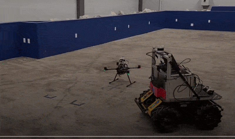
Cooperative localization of multi-agent systems in GNSS-denied environments.
CONSTRUCTION 🚧
I'm Uthman Olawoye, a PhD candidate in Aerospace Engineering at West Virginia University, working in the WVU Navigation Lab. My research focuses on cooperative localization of multi-agent robotic systems in GNSS-denied environments.
My work spans algorithm design, simulation, and real-world experiments — from underground tunnel navigation with UAV/UGV teams to search-and-rescue missions with the U.S. Air Force, and NASA's lunar robotics challenge.
Before WVU, I gained industry experience at Qualcomm's Location Technology Team in Santa Clara, taught control systems in Nigeria, and built automation systems in manufacturing.
AmiShare P2P comms integration, autonomous cooperative flights via Ardupilot/MAVROS, localization validation for UAV & pedestrian tracking.
FGO for drone localization + SLAM for UGV navigation in GNSS-denied subterranean environments. Published: NAVIGATION Journal vol.71 no.4 (2024).
7,000+ annotated LiDAR scans, PointPillars deep learning — +30% accuracy improvement over traditional methods. IEEE/ION PLANS 2023.
Developed FGO testing framework for precise position/velocity estimation, integrating GNSS and motion sensor data. Santa Clara, CA.
Open to research collaborations, industry roles, and conversations about robotics & navigation.
| uthmanwoye@gmail.com | |
| 🏫 LAB | WVU Navigation Lab, Morgantown WV |